Usually, this isn't the part of the year where a cyclone forms in the Atlantic Basin.
However, this one did. It is called Alex.
It is way out there, closer to Africa than the Americas and isn't forecast to be much stronger as it scoots off to the north in the next few days.
Any cyclonic storm is dangerous. It's bad weather, it's winds, torrential rain, storm surge and worse. I am quite sure shipping is aware and stays away. A relevant lesson from Hurricane Joachim.
Late in the season, ends on Nov 30th, this cyclone formed in the east Pacific off Mexico.
It is a fairly strong storm but is forecast to encounter shear and that will weaken it severely. It will hit Baja or the mainland coast of Mexico, bringing high winds and lots of rain. I reckon if you live by the ocean, you come to expect things like this.
I dearly want to visit Baja one of these days.
I hope no one is injured or killed and property damage is minimal.
I cannot say if this is the last tropical cyclone of the season. The weather doesn't obey human schedules.
I haven't talked about a storm now and in the latter half of Hurricane Season, I should talk about one.
This beast is making life difficult in the Bahamas. it will sit in this area for a few days. That isn't good but what it does later, out to 5 days, is what worries many.
It is liable or not to strike a densely populated part of the USA. Parts where it has rained a lot already. This beast is intensifying and by the time it hits or not, it could rival Sandy.
No one wants that. I hope it heels off to the east in the North Atlantic like some models suggest. Won't know until it actually moves.
I hope no one is hurt.
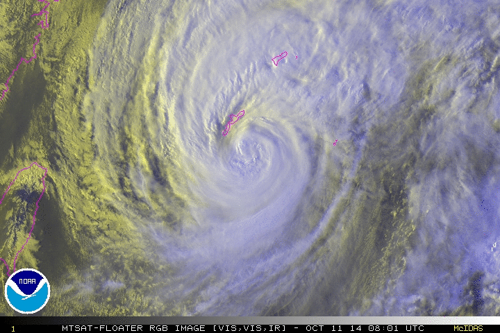
This is Typhoon Nangka about to ravage the islands of Japan with big winds and massive amounts of rain.
I would imagine it is always a concern when one is from or lives on islands vulnerable to tropical cyclones, preparation is automatic.
I hope no one is hurt but things happen. It feels wrong to admire the storm's structure when it threatens such a populated area.
Time to talk about tropical storms again. Been a while.
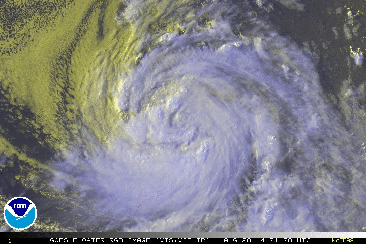
This is Dolores, in the Eastern Pacific. It has caused some problems.
It is moving northwest and should not be a factor as it moves into colder water which tropical cyclones do not like.
You know if you have read any of this blog that I like the weather. I like the sky, period. Day or night, especially.
I don't like sunlight. I am developing glaucoma and the light hurts, burns my fair skin in moments. Sunlight actually causes a panic reaction because it hurts.
I am fair skinned, you have seen pictures of my skin if you read this blog. I have freckles still, and I will be 40 around Thanksgiving time.
That is not the point here.
The point is, there are some huge supercell thunderstorms in this area, north of here. Confirmed tornadoes. It is that time of year and the weather has been behaving strangely. It hasn't been really hot yet and I remember many Spring times when it was scorching.
Thunderstorms don't stroke my anxiety disorder, they beat it with a stick. I have memories of bad storms through here when the power went out. That causes a panic attack as surely as a girl talking to me would.
Thankfully, none of the truly bad storms will hit this county. It isn't even raining at the moment.
You see, knowing a lot about the weather opens a fear of it, knowing what it could do.
I will be mindful of the situation north of here and hope no one is hurt.
I haven't discussed a tropical storm in a long while. There have been several in the Pacific and Indian Oceans.
Hurricane season here starts on the first of June and runs to the end of November.
This one is in the mid-West Pacific and heading north of the Philippines, which just was hit by Typhoon Maysak, which isn't very photogenic now.
Conditions for this tropical storm are unfavorable so, hopefully, it will dissipate before causing too many problems. That is good.
This beast is hitting the Philippines as I write this. 150+mph winds and rain like a deluge.
I don't like storms that hurt people.
I like Filipino people, my first gf was Filipina. I don't want anyone to get hurt by this cyclone but it always happens. I can't say what life's like there. Never been there.
This storm will pass over the islands and continue on to northern Indochina or even China, weakening before it hits as it encounters shear.
I will hope no one is killed by this storm. It is late in the year to feature a storm like this but the weather never stops.
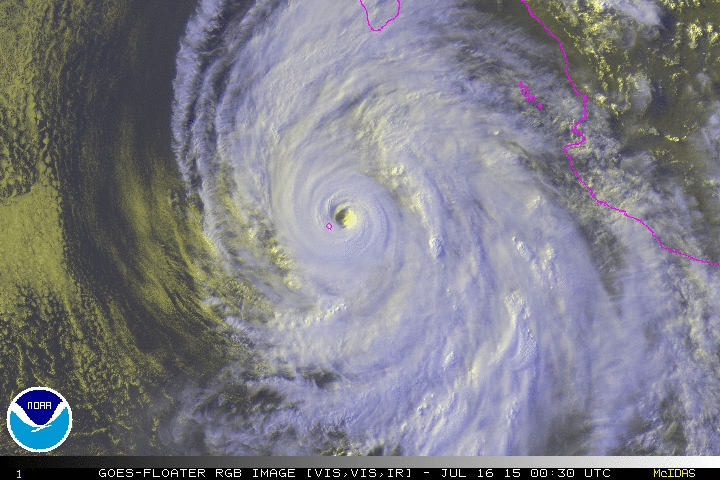
This is Category 3 Hurricane Gonzalo.
It is in the Atlantic Ocean, those islands in this picture being the Bahamas and Hispaniola.
It is heading north-northwestward at 5 mph, about to be deflected by a trough in the Eastern USA. That will put it on a more northerly track and cause it to come close to or hit the island of Bermuda.
The eye is fluctuating, causing the intensity of this cyclone to fluctuate. It will soon pass into drier air and over sharply colder water within a few days, becoming extra-tropical.
I am sorry it is not a beautiful RGB image. The RGB feed had a sharp distortion in it.
I hope Bermuda is spared the worst and no one is hurt.
This is dangerous Typhoon Vongfong ravaging Okinawa now and is heading to Japan.
I don't like cyclones that harm people.
Its swirly beauty is ruined by that, actually.
I have not forgotten, I just didn't post tropical cyclone pictures because I was feeling bad. I hope Vongfong doesn't kill anyone and damage is limited.
Another tropical cyclone to mention on this Hate Sunday.
This dramatic picture is of Edouard, Category 1-ish, in the Atlantic.
It is forecasted to strengthen in the next few days.
This storm will be deflected from the USA by an atmospheric trough and will cross the Atlantic, get caught up in the Westerlies, accelerating and becoming extratropical. It will eventually pass over cold water and dissipate.
What is with these funny names? I guess the good ones are already taken.
This is a beast of a cyclone. Odile, in the Pacific, just south of Baja California.
Category 4, strength has leveled off and it has a double eyewall, which can cause intensity to fluctuate.
It will go parallel to Baja, buffeting its west coast with heavy rain and big winds. I hope people take precautions as I write this.
The danger isn't just from the wind, extremely heavy rains can cause flash flooding which always creates problems.
This storm will pass into drier air and colder water, which are harmful to a tropical storm. After dissipation, it will cause heavy rain in the American Southwest, hopefully in California where they need it so.
This is Hurricane Norbert, Category 3, off the coast of Baja. It is a powerful storm but it is weakening as I write this, crossing into cooler waters.
It is forecasted to weaken and join upper level ridging over Northern Mexico and the American Southwest, creating heavy rain with its remnant moisture. It can't come to Texas, can it? We need
the rain.
It makes for a swirly picture of a tropical cyclone, something to appreciate on an otherwise unhappy day.
This is a beautiful swirly cyclonic storm. It is Hurricane Marie in the Eastern Pacific.
This storm is moving northwest away from land.
It is due to cross into cooler sea temperatures which will weaken it gradually.
The danger of this storm is the storm surge it causes, harsh waves and rip currents on the Pacific coast from Baja up to California and the Northwest.
I cannot swim myself but when I was a kid, we went to Corpus Christie, North Padre Island and I was in the Gulf of Mexico. We were warned about riptide and currents. I stepped on a jellyfish then, and I haven't gone barefooted anywhere since. That really hurt.
This storm is not a danger to land, just the usual ocean traffic whom I assume takes care when traveling.
Personal issues aside, let us look upon Tropical Storm Lowell in the Pacific. It is about 150 miles west of Baja California moving northwest.
It is doomed to dissipate because of cooler seas in its path and upper level ridging that has drier air. It will not be a threat to land but ships, I am sure they give such storms a wide berth.
This is Tropical Storm Karina, out in the Pacific.
Dry air is affecting it and it may intensify a bit as it moves westward, it will run into cooler seas and that inhibits storm development. This storm has around 40-60 mph winds and is staying together despite the dry air layer. It may not be more photogenic than this. I like the clouds myself.
That land in the right side of the picture is Mexico. It is moving westerly away from there.
This is Category 2 Hurricane Julio in the Pacific, heading near Hawaii.
I know next to nothing about Hawaii so I don't know what happens there. I am sure they prepare for storms like anyone else would. Hurricanes can dump prodigious amounts of rain on a location. The winds are terrible.
I hope this one misses the islands as its forecast track takes it north of them. However, a weakened Iselle is hitting the islands now.
I wonder why the Atlantic Basin has been relatively quiet. Of course, we like it that way.
This is a Category 2 hurricane with the attractive name of Iselle.
It is in the Eastern Pacific, about 1000 miles from the Big Island of Hawaii.
It is not a danger to land but I wonder if vehicle traffic avoids such storms when at sea. It is only pragmatism to avoid. There is a tropical storm in the Atlantic Basin but it is not photogenic yet, not recognizably a swirly low pressure pattern yet.
Talking about tropical storms is much better than the drip drip of my mental and body problems, is it not?
Look at this beast. I almost missed talking about this one. You know, it is on the far side of the planet.
This beast is Super Typhoon Rammasun.
It is a monster, Category 5, a kin of Katrina. That is southern China in its path. I hope people have made preparations and evacuated if needed. I don't like it when people suffer. This storm is like nature's wrath.
It is south of Okinawa, heading NNW. Its track takes it over Okinawa and into southern Japan.
It is a monster, Category 4.
I hope no one is hurt and gosh, damage seems unavoidable. A monster storm like this wreaks mayhem no matter where in the world they are.
Typhoon Neoguri will eventually pass into cooler seas and become extratropical and dissipate later in the week but not before making life difficult for a few days.


.gif)